


By James M. Arnold, Weather Specialist
Everything appears to be on track for the current storm.? Snow should begin in central Massachusetts later this morning and become heavier for a time around or just after noon.? It will all end in the early evening hours, as the developing storm really intensifies out in the Gulf of Maine.? Current radar shows the precipitation pattern as currently fragmented, but it should consolidate as the storm deepens as it heads off to the northeast.? This should happen late enough in the process for us to avoid a substantial snowfall this time, and I am looking for a general 2 to 5 inch accumulation with isolated pockets of up to 6 inches, most likely in the higher ground communities to our north and west.?? The areas to the south of the Mass Pike will likely get the lower amounts, and coastal areas, Cape Cod and the Islands will see a small accumulation before snow changes to a wintry mix and/or rain.
Temperatures today will rebound from very cold early morning levels (1.9F at my home) to the low 30s this afternoon.? Tonight as skies begin to partially clear temperatures will fall back a little as the next system approaches.?? It will bring another round of snow or a wintry mix during the late morning which should transition to rain during the afternoon.?? However, I am becoming concerned that some cold air damming will develop and open the door for a period of freezing rain, especially in the colder valley locations.? This needs to be watched carefully.? The rest of the week should play out as outlined yesterday, with moderating temperatures and the potential for a significant rainstorm late Thursday night into Friday as a vigorous front with a wave disturbance running along it comes through.
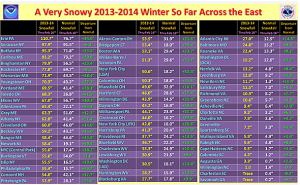
Below is a chart of snowfall totals so far this year through February 16th, average snowfall through February 16th and the departure from those averages.? Note the excess snow that both Worcester and Boston have had so far with yet another slug coming today.
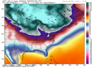
It is also looking like the cold that will have settled in here by the middle of next week really means business.? The map below (From WeatherBell Analytics, Joe Bastardi blog, 02/18/2014) is how the American (GFS) model sees the cold for the period ending February 27th.? If it is correct, the end of February and the beginning of March will be seriously cold.
?
James M. Arnold is a Weather Specialist working with Shrewsbury Emergency Management Agency; town of Princeton; Worcester Emergency Communications and Emergency Management Agency; Southborough Emergency Management Agency; town of Grafton and Wachusett Mountain Ski Area


