


By James M. Arnold, Weather Specialist
 Region – It looks like we are also setting up for the snow equivalent of “death by a thousand cuts”, as beginning Saturday afternoon, central Massachusetts will come under the influence of at least two minor weather system that will bring snow our way during Saturday afternoon and again Sunday morning. There will also be a northeast wind throughout the period which will augment the snow from the two systems and will also cause snow to continue lightly during the period between the two minor systems. This will continue into Sunday night and while none of these events will be particularly noteworthy, they will be responsible for bringing accumulations of 5 to 10 inches to much of our region by then. Then, on Monday (what else) a more organized and important system will be forming off the southeast coast and will begin to move in our direction. There are still too many moving parts to this to predict a track with any certainty for this storm, but it does have the potential for a significant impact on much of the state of Massachusetts and could extend our snowy period into Tuesday afternoon..
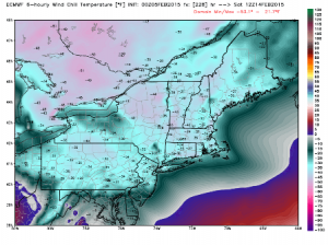
I have attached some of the European model guidance for 9 days out that is touting some severely cold wind chill values. It has been pretty consistent for a few runs now and it will be interesting to see if that sort of extremely cold air will be delivered to our area.
James M. Arnold is a Weather Specialist working with Shrewsbury Emergency Management Agency; town of Princeton; Worcester Emergency Communications and Emergency Management Agency; Southborough Emergency Management Agency; town of Grafton and Wachusett Mountain Ski Area


